Maps

Thursday, December 24, 2015

ICELAND SAGA PART III


"What saves a man is to take a step. Then another step. It is always the same step, but you have to take it."
Antoine St-Exupery, Wind Sand and Stars


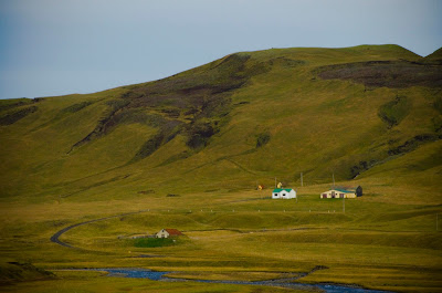
Apologies for the long and inexcusable delay. The loop around the north-eastern portion of the island turned out to be one of the most scenic portions of the island. It's mostly devoid of settlement and dramatic, with steam vents hissing between glaciers and lakes and forests. So without further ado . . .


Sunday, November 22, 2015

ICELAND SAGA: DAYS 3-4 AND A LIFE UPDATE


Before we move back to Iceland, a quick note. I've gotten a new assignment starting late next year, so I'll be in Washington DC for two years starting sometime next fall. I'll publish more specifics when they're formalized. And now, back to Iceland for the days between Selfoss and Hofn.


The sheer volume of water present in Iceland is shocking, especially coming from drought stricken Sao Paulo and very dry California. There are waterfalls everywhere. Everything is green. Even the homes, which for centuries were roofed with turf. After seeing a turf shod Keldur village, we visited the row of waterfalls beginning with Seljalandsfoss and ending with Gljufrafoss ('the one which lives in the canyon').

Seljalandsfoss

Keldur
The waterfalls are fed by glaciers, so in the interest of science and riparian research we hiked through the Solheimajokull, one of the several glaciers covering most the southeastern portion of the island. We were well guided by Olaf, who was exactly who you're imagining now: bearded and wearing a wool sweater.


Iceland has the population of a neighborhood in Sao Paulo, and it shows most prominently in a town like Vik. Vik is large-printed on maps of the country, but in reality has about 7 streets and a few thousand people. In between this outpost and the other metropoli ringing the coastline are lava fields, a plane crash, sheep, glaciers, and splendorous canyons.


The entirety of Vik

Sunday, November 8, 2015

ICELAND SAGA DAYS 1-2


"A tale is but half told when only one person tells it"
Saga of Grettir the Strong

Pingvellir
After a week of California, there was only one place I could think of that could improve my R&R. With a huge hat-tip to Kristen Svozil, who is the finest trip-planner in the world and very very patient with me, I did a lap of Iceland. It's one of the most photogenic place I've ever been, so there will be multiple posts. 
Reykjavik from the top of the steeple
Days one and two included the Blue Lagoon, excellent dinner and some spire ascending in Reykjavik, and the Golden Circle. Kristen and I were surprised to find the Blue Lagoon listed as one of National Geographic's top 25 natural wonders of the world in 2012. The surprise wasn't because it's not great. It is. It's because it's the runoff pool for a geothermal plant. So it's not natural, in the strictest sense at least. And, when you're there, it does not have the same jaw dropping effect that other places on the list have (Borneo rain forests, crystal caves, and the Rift Valley, for example).  I suspect no other wonder's Wikipedia entry describes a wonder as being "situated close to the worlds first renewable methanol plant". But I could be wrong.

Pingvellir
The Golden Circle is the common 1-3 day Iceland stopover route. It is hit and miss, in my opinion. The crater lake and geyser, for example, are impressive only to those who haven't seen Crater Lake in Oregon or Yellowstone. Pingvellir, however, was delightful. It speaks highly of Icelandic people that the site where their government was formed 1000 years ago is so staggeringly bucolic. Gulfoss was similarly impressive, though substantially less peaceful.

A ship lost on land near Grindavik

Reykjavik

The Great Divorce . . . the European plate is on the left, the American plate on the right

Gulfoss

Cemetery in Pingvellir

Street art in Reykjavik

Lighthouse on the southern coast

Shipwreck near Grindavik


Gulfoss


Wednesday, September 2, 2015

THE WISDOM OF THE SANDS


"For the travelers, stars are guides. For others they are nothing but tiny lights"
Antoine St. Exupery, The Little Prince


And now something entirely different. The last post was about the world's largest fresh water system. This post will be about one of the most unique things I've ever seen: the worlds friendliest sand dunes, the Lencois Maranhenses. The northern state of Maranhao is rarely on itineraries for travelers in Brazil. It's far away from Rio, Salvador, the gold towns of Minas Gerais, and is not the Amazon. But perhaps it deserves more credit than its given.


We started by flying into Sao Luis, which I was surprised to hear from our guide was Brazil's fourth largest city. I was surprised mostly because Wikipedia lists it as Brazil's 16th largest city (after two Sao Paulo suburbs no less). Our guides would continue to patriotically inflate Maranhao's importance in the world throughout the trip, usually in categories that were easily verifiable. Across a tumultuous channel by sailboat lies the colonial town of Alcantara and Brazil's space program headquarters. The museum for the space program, in addition to being housed rather incongruously next to a 16th century church and a place that sells batteries individually, featured exhibits constructed of posterboard and blown up photos of launches, and an old machine with some phones attached to it. Brazil's space program is the world's fourth largest, said the guide.


The sand dunes are a national park, and once inside the park you can only hike. We chose the 'death march' version, doing two full days of hiking on the dunes. To avoid the wind and sun, hikes begin at 3AM, when the stars and the moon cast a soft glow across the sand. The night hiking was perhaps the best part of hiking, the most serene and most beautiful, and the least possible to capture on a camera. But these dunes are friendly, even during the day, and the temperature was reasonable, the sand cool, and there were plenty of pools to jump into when it was time for a break. 


There's water everywhere. If you dug a foot into the sand at some places water would flood in. But the harshness of the sand keeps plants from growing. But it didn't keep rivers from flowing, and after many hours of hiking, we rode up one of the rivers, passing several towns that cling to the edge of the dunes and seeing the occasional Japanese tour group (they apparently love this place), and then we were back in Sao Luis.


Sao Luis, recently downgraded to the sixteenth largest city in Brazil by facts, is still one of the older cities in Brazil. It is frequently stated to be an island, especially by the guide, though it appears on the map to me to be a peninsula. The French founded it in the early 1600s, only to lose the fort and town within 20 years. Its age makes the old city an architectural gem, and its selection of tile-covered buildings is a delight to those of us who like tiles. Still, despite being (according to our dubious guide and not confirmed by real facts) the second most important port in Brazil, it has a run down feel to it. There are new parts of the city, but for the most part it feels like a city falling a bit behind. Maranhao mostly exports commodities, and as China and the commodities market have cooled down, there's  a definite cooling down of the city as well,


More to come soon . . . Chile and Rio de Janeiro!